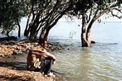
Lake Tana, the largest
lake, in Ethiopia is the source and from where the famed Blue Nile starts
its long journey to Khartoum, and on to the Mediterranean. The 37 islands
that are scrattered about the surface of the Lake shelter fascinating
churches and monasteries, some of which have histories dating back to the
13th Century. However, it should be noted that most of the
religious houses are not open to women. The most interesting islands are:
Birgida Mariam, Dega Estefanous, Dek, Narga, Tana Cherkos9, Mitsele
Fasiledes, Kebran and Debre Maryam.
Kebran Gabriel is the
principal monastery visited by male tourists from Bahir Dar, with its
impressive Cathedral-like building first built at the end of the 17th
Century. Dega Estephanos, which is also closed to women, is on an island
in the lake, and the monastery is reached by a very steep and winding
path. Although the church is relatively new ( only hundred years old) , it
houses a Madonna painted in the 15th century. However, the
treasury of the monastery is a prime attraction, with the remains of
several Emperors, as well as their robes and jewels.
On the banks of the lake
are many more religious houses, such as Ura Kidane Mehret and Narga
Selassie, many of which are aslo open to visit by women.
Near Gorgora, at the
northern end of the lake , the Susneyos palace is a forerunner of the
magnificent palaces and castles of Gonder, and dates from the reign of
Emperor Susneyos. In the same area the medieval church of Debre Sina
Mariam is particularly important.
A sail or cruise on lake
Tana is one of the most pleasant excursions for visitors to this region,
particularly in the heart of the summer. Boats can be hired from the
Marine Transport Authority in Bahir Dar.
Along the lakeshore
birdlife , both local and migratory visitors, make this a an ideal place
for birdwatchers.
Birdlovers will not want
to miss Fasilidas island, which is especially famous as an important
wetland. The whole of the lake Tana region and the Blue Nile Gorge have a
wide variety of birds both endemic and visitors. The variety of habitats,
from rocky crags to riverain forests and important wetlands, ensure that
many other different species should be spotted.
Awasa Lake
At about 275 km from Addis Ababa a gravel road on the right runs along the
shore
of Lake Awasa to the two or three resort hotels. The luxury Awasa
Hotel, is the most comfortable. Simpler accommodation at the Bekele Mola
Hotel, and the more interesting Belle Vue du Lac (also with swimming pool
and a tennis court) is quite adequate. Fishing and boating are favourite
pastimes on LakeAwasa, although again the bird watching, if not as spectacular as
Abyata, has its own special attractions.
Chamo and Abaya Lakes
Far
south in Ethiopia's
Great Rift Valley lie two marvellous lakes ringed by savanna plains and
smoke; mountain crests. By far the largest of Ethiopia's Rift Valley
lakes, the 551-square-kilometre waters of Chamo and the
1,160-square-kilometre surface of Abaya are considered by many to be also
the most beautiful. Indeed, few places on earth can match the allure of
their setting.
Much of this forms part of one of Ethiopia's finest national parks, Nech
Sar, established as a sanctuary for the rare Swayne's hartebeest. From the
town of Arba Minch
on the ridge of land that divides Abaya and Chamo there are commanding
views of the panorama all around including both lakes with Nech Sar on the
eastern side and, to the west, the Guge range of mountains. Such is the
outstanding beauty of this viewpoint it has long been known as the Bridge
of Heaven. Equally poetic, Arba Minch -meaning Forty Springs in Amharic
-takes its name from the bubbling streams which spring up amid the
undergrowth .of the luxuriant forest which clothes the steep slopes
beneath the town.
This region, more than 500 kilometres south of Addis Ababa, is one of
Ethiopia's last great surviving wildernesses. But an international hotel
at Arba Minch with high-quality service and facilities ensures the visitor
enjoys the splendours of nature in comfort.
This is an ideal base from which to explore the forested land between the
lakes, and the plains of Nech Sar beyond where the surviving herds of
Swayne's hartebeest, once in abundance, and zebra and Grant's gazelle roam
the high savanna.
There's an air of untamed grandeur about all this that lingers over the
lakes and mountains. Alive with many species of fish -the fighting
tigerfish, giant Nile perch, barbel, catfish and tilapia offering fine
sport -
Chamo and Abaya are an angler's paradise. In the reed-fringed bays of
Chamo's sparkling aquamarine waters hundreds of hippos emerge at night to
graze on the grassy shores. Chamo is also sanctuary for several thousand
Nile crocodile, some reaching lengths of up to seven metres from snout to
tip of tail.
Birds Here the balance between predator and prey remains in equilibrium;
birdlife flourishes in equal proportion: hordes of yellow weaver birds
flit constantly through the trees, and vividly-coloured kingfishers skim
the lakes where Great White pelicans, storks; ibises, hornbills and
cormorants plumb the waters for food. With piercing echoing cries, black,
and white fish eagles swoop down from their tree perches to snatch up
unwary fish in their talons.
People Around the Lakes The shores and islands of Abaya and Chamo are populated by farming
peoples such as the Ganjule and the Guji, both of whom also have ancient
traditions of hippo hunting. The Guji ply the waters of lake Abaya in
high-prowled am batch boats similar to those depicted on the tombs of the
ancient Egyptian Pharaohs.
South-west of the lakes in the direction of Jinka, the traveller comes to
the homeland of the Konso who practice an intensive form of agriculture on
intricately-terraced hillsides. The Konso have a rich indigenous culture
that finds expression in haunting music and dance, and in the weaving of
beautiful thick cotton blankets.
Another distinctive people of the region around Lakes Chamo and Abaya are
the Dorze, once warriors, who have now turned to farming and weaving. They
produce the colourful toga-like robes known as shammas which are worn
throughout Ethiopia. Though there's a large Dorze population around Arba
Minch itself, their traditional homeland is further to the north around
Chencha, high up in the Guge mountain range overlooking the lakes and the
Bridge of Heaven.
The brief, 26-kilometre drive from Arba Minch up to Chencha involves a
remarkable transition – climbing from the lush, tropical forests of the
lowland, through bamboo at around 2,500 metres, into stands of juniper
laced with Spanish moss where cold fingers of cloud grasp the ancient
limbs of the trees and the air is chill and bracing.
Dorze villages are classic example of simple architecture, unlike anything
seen elsewhere in Ethiopia -towering beehive-shaped structures reaching up
to 12 metres high, the interiors dark but spacious and airy with floors of
pressed earth. The vaulted ceiling walls are covered with an elegant
thatch of ensete (false banana) to form a smooth and unbroken convex dome.
Each home stands in its own grounds surrounded by smaller but similar
houses: guest house; cow-shed, kitchen and perhaps even a workshop for
weaving or other work.
Northwards from Chencha, leaving Lake Abaya behind -and with it the
wilderness -the traveller eventually comes to the bustling market town of
Sodo, which stands on the border between the regions of Gamo Gofa, Sidamo
and Kaffa. This is one of Ethiopia's premier coffee-growing areas and,
quite possibly, the original home of the coffee plant –where, the first
trees grew wild before being cultivated and then, in the 14th century,
taken to Yemen and from there across the world.
Lake
Langano
At the Horacallo bridge it is possible to turn left along a track which
leads to the lake. There are good camping spots here along the northern
shore however, the main track to the lake is at about 210 and 215 kms
leading left to the Wabe Shebele and Bekele Mola Hotels, beach and camping
ground respectively:
The soft brown waters of Langano are set against the blue backdrop of the
ArsiMountains soaring4,000 metreshigh. A few birds make Langano their home
but this resort is less for the nature lover than sportsman and
sunworshipper. Here you can waterski and sail, swim or bask in the blazing
sun on the sloping sandy beach. European food is served in the hotel
restaurant but the tilapia is good and cooking freshly caught fish over
the camp fire has its own special attraction. The local Oromo women are
often prepared to sell jewellery or utensils; copper bracelets or brass;
bead necklaces and cowrie shell decorated milk pots.
Before reaching the turnoff to Langano lake, the road passes over the
Bulbula river. Just before the bridge and the village, there is a track to
the right (at the top of the slope) which leads to the lake edge. At
certain times of the year the greatest congregation of birds is to be
found here. However, before the next bridge, over the Horacallo river
(connecting Lakes Langano and Abyata) a turning to the right leads to the
more usual area of exceptional bird viewing.
Thousands of flamingos create pink carpets in the blue bays of the lake;
great white pelicans soar in from LakeShala to enjoy the fishing and execute their fantastic ballet;
pied kingfishers hover and dive; fish eagles protect their territory with
their eerie cry; cormorants and darters fill the dead acacia trees
silhouetting strange and beautiful shapes against the sunset. Here are
tall marabous, sacred ibis, dwell sometimes in the hundreds of thousands,
snipe, stilt, avocet, and the black heron searching the shallow water in
the shadow created by his black umbrella.
Zuqala Lake
A huge volcanic cone set isolated in the surrounding plain and
rising 600m Zuquala’s crater is still perfectly preserved. Two kilometres
across and sixty meters deep the crater is occupied by a shallow lake,
well known as a holy lake. For many centuries the rim has been the site of
a monastery. Mohammed Gragn destroyed one of the buildings but it was
rebuilt and is still in use today. The inside rim of the crater is covered
with juniper forest, the frequent swirling mists encourage a heavy growth
of trailing lichens and the beautiful black and white colobus monkey can
sometimes be seen, adding yet another dimension to this already
picturesque place. To get to Zuquala, it is possible to turn off the Addis
Ababa-Bishoftu road at Dukem 35 km. from the city, or to turn off near
Bishoftu at Dirray. The latter is probably the more used track at the
present time, it is about three hours walk or fifty minutes drive to
Wember Mariam at the base of the mountain. It is possible to drive to the
top, but check conditions before driving it as it can be a difficult road.
Zway
Lake
Lake Zway is 26 km. long and 18km, wide and several islands dot
the surface of the largest of the five lakes. There are several turnoffs
leading to the lake shore Tall fig trees line the original shore, but in
recent years the level of the lake has dropped to such an extent that
several hundred metres of grassland and reeds come between you and the
water. Marabou storks roost on the tops of the acacias in the evenings,
and many other birds have made the grassy stretch their feeding area. On
the north side of the lake where the Meki river flows in lies HippopotamusBay. To reach the far shore or any of the islands it is
necessary to bring a boat.